GEOGRAPHY
Table of Contents
Geography Bullet Points

UNIVERSE
- The Universe includes planets, stars, galaxies, the contents of intergalactic space, the smallest subatomic particles, and all matter and energy. Estimated age of the universe is about 13.82 billion years. The study of universe is known as Cosmology.
- The Big Bang theory is the most accepted explanation about the origin of universe. As per this theory, all matter was condensed into one point. Later this point exploded and started expanding and thus we have the present universe.
Galaxy:-
A galaxy is a huge system of billions of stars, and clouds of dust and gases. There are millions of such galaxies that make the Universe.
- Our solar system is a part of a galaxy called Milky Way or Akash Ganga
Solar system
The sun, the eight planets along with their respective satellites, the asteroids and meteoroids, the comets, the interplanetary dust and the electrically charged gases called plasma, together make up the solar system.
The Sun: The Sun is at the centre of the solar system and it is the nearest star to the sun.
Planets: All the 8 planets (Mercury, Venus, Earth, Mars, Jupiter, Saturn, Uranus, and Neptune) of the solar system move around the sun in a fixed path. These paths are also called as orbits
➢ One Astronomical Unit (The average distance between then Sun and the Earth) = 150 million km
➢ Nuclear Fusion reaction is going on inside the Sun. In this process, two hydrogen atoms combines to form a helium atom. The energy released during this process is emitted and the solar energy which reaches our planet is part of that energy.
➢ Time taken by sunlight to reach the Earth = 8 min and 20 sec.
Mercury
➢ Also known as swiftest planet
➢ Nearest planet to Sun
➢ Smallest planet
➢ It has no atmosphere
➢ It doesn’t have any moon
Venus
➢ Also known as evening or morning star
➢ It is also called Earth’s twin
➢ Hottest planet, because of the presence of carbon dioxide in its atmosphere
- Nearest planet to earth; Also doesn’t have any moons
Mars
➢ Also known as Red planet
➢ It has two moons, Phobos and Deimos
Jupiter
➢ Biggest planet
➢ It has fastest rotational velocity; has 79 known moons identified by scientists
➢ Its satellite, Ganymede is the largest and heaviest of all satellites in the solar system
Saturn
➢ It is surrounded by a set of seven rings which are made up of primordial dust and ice particles
➢ Its planet Titan, is the only satellite in solar system with an Earth like atmosphere;
➢ It has 82 moons identified by scientists.
Uranus
➢ Also known as Green planet
Neptune
➢ Coldest planet; Farthest planet from sun
Earth: Conditions favourable for life are probably found only on the earth.
- Two-third of earth’s surface is covered by water and hence it appears blue from outer space. That is why
earth is also known as Blue planet.
- Moon is the only natural satellite.
- Earth is slightly flattened at the poles and hence its shape is also described as Geoid.
Earth’s statistics( Geography Bullet Points)
Age About 4.5 billion years
Distance from sun 150 million km
Water Area 71% of total surface area
Rotational time period 23 hrs 56 min 4 sec
Revolutionary time period 365 days 5hr
Equinox (Dates when days & nights are equal)
March 21 (Vernal equinox)
September 23 (Autumnal equinox)
Summer solstice (Longest day in northern hemisphere)
21st June Winter solstice (Longest day in southern hemisphere)
22nd December Tilt of Earth’s imaginary axis 23.5O Escape velocity (It is the minimum speed needed for an object to “break free” from the gravitational attraction of earth) 11.2 km/s
Moon: It is earth’s only natural satellite.
- Neil Armstrong and Edwin Adrin were the first human being to set foot on the moon’s surface in 1969.
And the landing spot was later called “The Sea of
Tranquility”
- Lunar Eclipse: Takes place when moon passes through the shadow of the Earth, i.e. the earth is in between moon and sun. A partial eclipse occurs when only a part of the moon passes through the shadow
- Solar Eclipse: This eclipse happens when the moon passes between the sun and the earth, and the moon fully or partially blocks the Sun.
- Blue Moon: It is a rare celestial phenomenon marked by the occurrence of the second full moon within one month.
- Since moon’s rotational and revolutional time periods are same, we see only one side of moon always.
Asteroids: Apart from the stars, planets, and satellites, there are numerous tiny bodies which also move around the sun. These bodies are called asteroids. They are found between the orbits of Mars and Jupiter. Largest asteroid is Ceres.
Meteoroids: They are the small pieces of rocks which move around the sun.
- Sometimes these meteoroids come near the earth and tend to drop upon it. During this process due to friction with the air they get heated up and burn. It causes a flash of light, called meteor shower.
- Sometimes, a meteor without being completely burnt, falls on the earth and they are called meteorites.
WORLD GEOGRAPHY
Latitudes and Longitudes:-
They are imaginary lines drawn on the surface of the earth. And these lines make it easier to locate any place on the surface of the earth.
- Equator: Imaginary line which divides earth into two equal halves, northern and southern hemispheres.
Equator is the reference latitude and hence it is the 0o latitude
- Parallels of latitudes: These are parallel circles drawn from the equator up to poles. Parallels divide the earth into various heat zones. The different zones have different types of climate and vegetation.
- Meridians of Longitudes: These are the imaginary lines, drawn from pole (North Pole) to pole (South Pole). Naturally, there is no reference longitude, hence we have fixed a longitude passing via the Royal Observatory, Greenwich, in London. And this reference longitude is also called Greenwich meridian or Prime meridian. Prime meridian divides earth into eastern and western hemisphere
Important latitudes
Equator 0o
Tropic of cancer 23.5o N
Tropic of Capricorn 23.5o S
Arctic circle 66.5o N
Antarctic circle 66.5o S
North pole 90o N
South pole 90o S
Important longitudes
Prime Meridian 0o
Indian Standard Time (IST) 82.5o E
International Date Line 180o
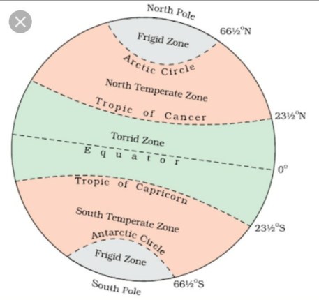
Heat Zones
Earth System
Earth has four main systems that interact and they are geosphere, hydrosphere, atmosphere and biosphere
- GEOSPHERE
Continents Highest and Lowest Points
Continent Rank (by Area)
Highest Point Lowest Point
Asia 1 Mt. Everest Dead Sea
Africa 2 Mt. Kilimanjaro Lake Assal
North America 3 Mt. McKinley Death Valley
South America 4 Mt. Aconcagua Laguna del Carbon
Antarctica 5 Mt. Vinson Massif Bentley Subglacial Trench
Europe 6 Mt. Elbrus Caspian Sea
Australia 7 Mt. Puncak Jaya Lake Eyre
Rocks
Various kinds of rocks found on earth’s crust are grouped under three families i.e. igneous rocks, Sedimentary rocks, and metamorphic rock.
- Igneous Rocks: When the molten magma present inside earth comes to the surface as a result of volcanic activity, it cools and forms Igneous Rocks. Granite and Basalt are examples for this type of rocks.
- Sedimentary Rocks: They are formed as a result of weathering, erosion, deposition and compaction of igneous rocks and other materials, through agents like wind, water, ice, and chemicals. Gypsum, Gravel etc. are examples for these kinds of rocks.
- Metamorphic Rocks: These types of rocks are formed from igneous or metamorphic rocks,
under great pressure and heat. But under very high temperature they are melted and they become part of magma. Later during volcanic activity this magma will again rise to the surface, cool down and solidify, forming igneous rocks. This complete cycle or the conversion of one type of rock into the other is known as Rock cycle.
- HYDROSPHERE
Oceans
Oceans and their features
Ocean Rank(by Size)
Features
Pacific Ocean 1 Spread over 1/3rd of the earth’s surface Circular in shape – Mariana Trench is the deepest point
Atlantic Ocean 2 S’ Shaped – From commercial point of view, this is the busiest ocean – Deepest point is Puerto Rico Trench
Indian Ocean 3 Trangular shaped – Only ocean named after a country – Deepest point is Java Trench
Antarctic Ocean 4 Also known as Southern Ocean – Deepest point is South Sandwich Trench
Arctic Ocean 5 Located within Arctic circle and surrounds North Pole – Berring Strait connects Pacific and Arctic oceans – Molloy Hole is the deepest point.
Bermuda Triangle: It is a vaguely defined triangular region of Atlantic Ocean, where many aircrafts and ships have said to be disappeared under mysterious circumstances. But some of this is inaccurate and there are many other place on earth where more number of ships and other vessels disappear.
Tides: It is the periodic rises and falls of large bodies of water caused by the gravitational interaction between earth, moon and sun. Based on the position of the three celestial bodies, tides can be of two types, Spring tide and Neap tide
- Spring Tide: It occurs on new moon and full moon days. They are large because the gravitational pulls of the moon and sun are in the same direction. Spring tide occurs on full moon and new moon days
- Neap Tide: Normally there is a seven day interval between the spring tide and neap tide. In this case the gravitational pull of the sun is in right angle to that of the moon. During the Neap tides, high tide is lower and low tide is higher than usual. Neap tide occurs on the first and third quarters moons
- ATMOSPHERE

( Geography bullet Points)
Atmosphere is the gaseous layer, surrounding earth. It is earth’s gravity which is holding these gases close to earth. Since force of gravity (earth’s pull) decreases from the surface, the concentration of gases also decreases with the increase in altitude from the surface. As a result atmospheric pressure is maximum on the surface of the earth and decreases with increasing altitude. Barometer is used to measure atmospheric pressure.
Based on the gaseous composition and temperature profile, earth’s atmosphere is divided into 5 layers.
- Troposphere: This layer is closest to the surface of earth. In this layer, with increase in altitude, temperature decreases. Almost all weather phenomenon happens in this layer. There is a small region between troposphere and stratosphere where temperature does not change and this region is known as Tropopause.
- Stratosphere: With increase in altitude, temperature also increases in this layer. Presence of Ozone layer is the most important speciality of this layer. Stratopause is present between Stratosphere and Mesosphere and here temperature doesn’t change.
Highest tide in the world occur in the Bay of Fundy in Nova Scotia,
Canada
- Strait: It is a narrow channel of water that connects two large bodies of water. Strait of Hormuz, Palk Strait etc. are examples for a strait.
- Isthmus: It is a narrow strip of land connecting two large land areas usually with waterbodies on either side. Isthmus of Panama is an example for an Isthmus
Coral Reefs
Coral reefs are formed as a result of the deposition of skeletons and secretion of microscopic marine organisms known as Coral Polyps. They live in colonies and are mainly of three kinds. Barrier reef, Fringing reef, and Atolls.
- Mesosphere: Again with increase in altitude, temperature decreases and in Mesopause, temperature is constant.
- Thermosphere: Temperature in this layer increases with increase in altitude. Another speciality of thermosphere is Ionosphere. It is a layer of charged particle. We make use of Ionosphere in radio communication. Thermopause is also present.
- Exosphere: Last of the five layers. Outer boundary of exosphere is not defined, it slowly merges with the outer space.
- BIOSPHERE
It is the narrow zone where all other earth systems meet and interact with each other. It is the biological component of the Earth Systems and it contains and supports living organisms. Even though geosphere constitute 82% of the total mass and biosphere is 0.0007 percent of the volume of the planet, which has a 6371 kilometer radius. Without the biosphere, life on earth wouldn’t have originated.
INDIAN GEOGRAPHY
- PHYSIOGRAPHIC DIVISIONS OF INDIA
The main physiographic features of India includes, the Himalayan Mountain, Northern Plains, Indian Desert, Peninsular Plateau, Coastal Plains, and Islands.
THE HIMALAYAN MOUNTAIN
This young fold mountain ranges from north till north-eastern borders of India. Himalayas Consists of three parallel longitudinal ranges; Greater or Inner Himalayas or the Himadri, Middle Himalayas or Lesser
Himalayas or Himachal, and Outer Himalaya or Shiwalik.
- Himadri: This is the northern most range and most continuous of all the three ranges. It is also home to loftiest peaks including Mt. Everest.
- Himachal: It is composed of highly compressed and altered rocks. Pir Panjal, Dhaula Dhar, and Mahabharat are very famous ranges present here. It is also famous for many valleys including Kashmir, and Kulu valley. This region is also known for hill stations.
- Shiwalik: It is composed of unconsolidated sediments brought down by Himalayan Rivers. The longitudinal valleys lying between Himachal and Shiwalik is known as Duns. Dehra Dun, Kotli Dun and Patli Duns are some of the well-known Duns. The eastern most extension of Himalaya is known as Purvachal and it consists of Naga, Manipur and Mizo hills.
Geography Bullet Points which is easy to read and understand. it helps in exams to tick the right answer
Chlorofluorocarbons (CFC) is destroying Ozone layer and causing many health issues.
Montreal Protocol is related to the restriction over the usage and release of CFCs and
Hydrofluorocarbons (HFCs) chemicals like Stratosphere, is protecting earth from harmful ultraviolet radiation from sun, by not allowing it to reach earth’s surface. But Ozone Depletion Ozone layer present in Global Warming Global Warming is the increase in Earth’s average surface temperature due to effect of greenhouse gases (carbon dioxide, methane, ozone, water vapour, CFCs and Nitrous oxide). After receiving sun’s radiation, earth will be heated up and earth will also start emitting radiation which is known as terrestrial radiation. But the greenhouse gases present in atmosphere reflects this radiation and thus not allow this radiation to escape into outer space. And this process increases Earth’s average surface temperature.
Effect of global warming: Increase in pollution increases the greenhouse gases present in the atmosphere and this in turn causes global warming. As a result of this phenomenon agricultural productivity will decrease, increase in the frequency of occurrence of natural calamity, and abnormal weather changes.
THE NORTHERN PLAIN
Northern Plain was formed as a result of the alluvial deposition by the three main Himalayan Rivers Ganga, Indus & Brahmaputra and its tributaries. Because of the presence of fertile soil, availability of water, and moderate climate, these areas are best suited for agriculture and hence highly populated. Longitudinally northern plain is divided into four regions.
- Bhabar: This is the northern most region of the plain. Rivers in this region have pebble sized rocks and as a result, the water level above the rocks in rivers is very low. So normally it looks like rivers disappear in this region.
- Terai: This is just below Bhabar, and the rivers that disappear in Bhabar region, reappear in Terai region. This region is a swampy and marshy land.
- Bhangar: This region lie just above the flood plains of the rivers and has old alluvialsoil.
- Khadar: This is the flood plains of rivers, where new alluvial deposits are seen.
INDIAN DESERT
Also known as Thar Desert, is lying in the northwestern part of India. This area receives very less rain fall and the presence of sand makes it an arid region with very low vegetation. Luni River is the most important river of this region. The crescent shaped sand dunes seen in this region are known as Barchans.
Geography Bullet Points which is easy to read and understand. it helps in exams to tick the right answer
THE PENINSULAR PLATEAU
Plateau is a table top land. Indian Plateau is divided into two based on the position of River Narmada. Part of plateau lying north of Narmada is called Central Highlands and part lying south of Narmada is known as
Deccan Plateau.
- Central Highlands: In south it is bounded by Vindhyan range and north-west by Aravalis. The further westward extension gradually merges with the Thar Desert. Its eastern extension is known as the Bundelkhand and Baghelkhand.
- Deccan Plateau: This triangular land mass, in south west is bounded by Western Ghats and in South- East by Eastern Ghats. Anai Mudi is the highest peak in Western Ghats and Mahendragiri in Eastern Ghats. Western Ghat is more continuous and hence only with the help of a natural pass, anyone can cross it. On the other side, Eastern Ghat is discontinuous and can be easily crossed.
COASTAL PLAINS
India has Western Coastal Plain (between Western Ghats and Arabian Sea) and Eastern Coastal Plain (between Eastern Ghats and Bay of Bengal).
- Western Coastal Plain: It is divided into three sections. Northern most part of the coast is called the Konkan, the Central stretch is called the Kannad Plain while the Southern most part is known as Malabar Coast.
- Eastern Coastal Plain: It is divided into two parts. Northern part is known as Northern Circar and thesouthern part is called Coromandel Coast.
ISLANDS
India has two main groups of Islands; Lakshadweep Islands and Andaman and Nicobar groups of Islands.
- Lakshadweep Islands: It is composed of small coral islands and its administrative capital is Kavaratti Island. Pitti Island, which is a bird sanctuary is situated here. In India, Lakshadweep stands first in both coconut production and per capita availability of fish.
- Andaman and Nicobar Islands: Andaman and Nicobar groups of Island is separated by Ten degree channel. Its administrative capital is Port Blair and India’s only active volcano is located in Barren Island. It is believed that these Islands are an elevated portion of submarine mountains.
- RIVERS OF INDIA
Himalayan Rivers
Indus:-
- Origin: Near Mansarovar lake
- Tributaries: Satluj, Ravi, Beas, Chenab, Jhelum. At Mithankot these tributaries join the main Indus River.
- Indus water treaty: Treaty between India and Pakistan for sharing Indus water
Ganga:-
- Originates from Gangotri glaciers
- Tributaries: Yamuna, Chambal, Son, Kosi, Ghaghra, Gandhak
- Headwaters of Ganga, Bhagirathi and Alaknantha meet at Devaprayag
- Yamuna joins with Ganga at Allahabad
- Ganga flows east till Farakka in West Bengal and then takes a right turn and flows to Bangladesh. There Ganga meets Brahmaputra and from then onwards known as Meghna and finally joins Bay of Bengal. But these rivers form deltas at river mouth and they are known as Sunderban Delta (world’s largest and fastest growing delta).
Brahmaputra:-
- Origin: East of Mansarovar lake (Kailash ranges of Himalayas at an elevation of 5300 M)
- Flows eastward parallel to Himalaya. Since these regions are dry, river water level is low.
- When it reaches Namcha Barwa, river takes a ‘U’ turn and enters India in Arunachal Pradesh. Here it is called Dihang. Later Dibang, Lohit and many other tributaries join the many river and from then onwards it is Brahmaputra.
- After flowing through some of the North Eastern states, Brahmaputra finally enters Bangladesh and then meets Ganga and finally joins Bay of Bengal.
- Inside Indian Territory it flows through areas of very high rain fall and hence the water level in the river is very high. River carries large amount of silt in this region and that is why we can’t build a dam across Brahmaputra River.
Peninsular Rivers
East flowing rivers
River Godavari:-
- Largest Peninsular river and also known as ‘Dakshin Ganga’
- Rises from the part of Western Ghats in Nasik district of Maharashtra
- Main tributaries: Purna, Wardha, Manjra, Pranhita, Wainganga, and Penganga
- Flows through Maharashtra, Madhya Pradesh, Odisha, and Andhra Pradesh. Finally drains to Bay of Bengal.
Mahanadi:-
- Origin: from the highlands of Chhattisgarh
- Tributaries: Ong, Jonk, Telen, Hasdeo, and Mand
- Flows through Chhattisgarh and Odisha. And finally drains to Bay of Bengal
River Krishna:-
- Origin: From Mahabaleshwar, Maharashtra.
- Tributaries: Tungabhadra, Bhima, Dindi, Halia, and Panchganga
- Flows through Maharashtra, Karnataka, Telangana & Andhra Pradesh and finally drains to Bay of Bengal
Kaveri:-
- Origin: At Talakaveri, Kodagu in Western Ghats
- Tributaries: Shimsha, Hemavati, Arkavati, Kabini, Bhavani River, and Amravati River.
- Flows through Karnataka and Tamil Nadu and emptying into Bay of Bengal
West flowing rivers
Narmada:-
- Rises from Amarkantak hills in Madhya Pradesh and is also known as life line of Madhya Pradesh
- Flows westward through rift valley and empties into Arabian Sea.
- Tributaries: Kolar, Hiran, Shakkar, and Tawa
Brahmaputra is known as the Tsang Po in Tibet and Jamuna in Bangladesh. Sunderban delta area is the home of Royal Bengal Tiger.
Tapi/ Tapti:-
- Originates from the Satpura ranges of Madhya Pradesh and flows westward through rift valley
- Flows through Madhya Pradesh, Maharashtra and Gujrat
- Main tributaries: Arunavati, Gomai, and Panzara
Sharavati:-
- Originates at Ambuthirtha in Karnataka
- Flows westward within Karnataka and finally joins Arabian Sea
- Jog water falls are formed by Sharavati
River Luni:-
- Origin: Pushkar valley of Aravalli range
- Flows west, through Thar desert and finally joins the marshy land of Rann of Kutch in Gujarat
- Tributaries: Jowai, Sukri and Jojari
Geography Bullet Points which is easy to read and understand. it helps in exams to tick the right answer
- CLIMATE
Climate is the sum total of weather conditions over a large area for a long period of time. Climate of India is described as the ‘Monsoon type’. Because of the presence of coastal area peninsular India doesn’t experience much variation in temperature. Four main seasons can be identified in India.
- Hot Weather Season (Summer):-
➢ During this time of the year, because of the apparent movement of the Sun, sunrays fall directly over tropic of cancer and as a result temperature increases gradually. By May end or June starting, temperature of North Indian states increases up to 45-48 degree Celsius.
➢ North Indian states also experience a very hot and dry local wind during summer season. They are called loo. They are very dangerous and if we are exposed to it, it may even prove to be fatal.
➢ By the end of May, some areas receive localised thunderstorms and slight rainfall. They are also known as Kaal Baisakhi.
- Advancing Monsoon (Rainy Season):-
➢ South West Monsoon winds causes precipitation. Since these winds passes over Indian Ocean, it carries very large amount of moisture and this later results in heavy rainfall. Sometimes Monsoon experiences wet and dry spells.
- Retreating Monsoon (The Transition Season):-
➢ This is a transition season between Monsoon and Winter, and experienced during October-
November months
➢ October Heat (high temperature and high humidity) is the most important speciality of this
season.
- The Cold Weather Season (Winter Season)
➢ During this season, because of the apparent shift of the sun towards southern hemisphere, we will experience a Cold Weather Season.
➢ Because of the Western disturbance during this season, North-Western states of India receives some amount of rainfall, known as Mahawat. And this rain helps Rabi crops.
➢ Tamil Nadu coast receives some amount of rainfall during this season.
- SOIL
There are mainly six types of Soils seen in India. They are Alluvial soil, Black soil, Red soil, Laterite soil, Desert soil, and Mountain soil.
- Alluvial Soil: This soil is found mainly in Northern plains and Coastal plains of peninsular India. It is highly fertile and best suited for agricultural activity.
- Black Soil: They are originated from the basalt rock which are volcanic in origin. They are clay in character and as a result they can hold moisture for a long time, and this helps crops to sustain even during the dry season. Black soil is best suited for Cotton cultivation. They are rich in lime, Iron, magnesia and alumina.
- Red Soil: Presence of Iron Oxides makes them red in colour. They are not very fertile, but with adequate amount of fertilizer, they can be used for cultivation. They are found in eastern and south eastern part of peninsular India.
- Laterite Soil: Because of very high rainfall in Western Ghats and North-Eastern parts of India, Silica content of the soil leaches out and that soil will be deprived of humus too. This soil with a reddish colour is known as Laterite Soil.
- Desert Soil: They are mainly found in the arid regions of Rajasthan and Gujarat. Due to the dry climate, high temperature, and accelerated evaporation, they lack moisture and humus. Also known as Arid soil.
- Mountain Soil: Our mountain ranges have wide range of soils. The soils vary in structure and texture depending on the mountain environment where they are found. Also known as Forest Soil.
- CROPPING SEASONS IN INDIA
India has three main cropping seasons, Kharif, Rabi and Zaid cropping seasons.
- Kharif Season: Crops are cultivated and harvested during the rainy season. i.e. between June and September. Rice and millet are example for Kharif crops.
- Rabi Season: Crops are cultivated and harvested during the winter season. i.e between October and March. Wheat, barley, maize and oat are examples for Rabi crops. Mahawat (winter rain in the northeastern part of India) helps Rabi crops.
- Zaid Season: This season is between Rabi and Kharif. i.e. mainly from April to June. Water melon, cucumber and sugar cane are examples for zaid crops
Geography Bullet Points which is easy to read and understand. it helps in exams to tick the right answer